 Vessel monitoring system Vessel monitoring system
Deep-sea ecosystems are very poorly known but are increasingly affected by offshore human activities such as oil and gas extraction and intensifying deep-water fishing. Deep-water trawls can cause major damage to habitats that are thousands of years old. With the advent of deep-water Marine Protected Areas such as the Darwin Mounds off Northwest Scotland, it is important that suitable measures are in place to police these areas properly. Current methods employ a combination of spotter planes, naval vessels and onboard observers to monitor deep-water Marine Protected Areas, none of which are 100 % effective. From January 2005 all EU vessels have been required by law to carry satellite Vessel Monitoring Systems (VMS), which transmits positional data of fishing boats. At present these data are collated by each member state for the control and surveillance of fisheries, but are not widely used for habitat protection. VMS offers huge potential as a tool for spatial management, helping to conserve precious deep-water marine habitats (Hall-Spencer, 2002). In our study we are investigating the use of VMS data around the Darwin Mounds and around a heavily fished area to the west of Scotland, called Rockall Bank.

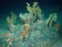
Deep-water coral garden on glacial drop stone, W Ireland. Image: AWI & IFREMER.
Click here for an overview of Deep-sea Fisheries. |
